Following an all-time low maximum in September 2023, Antarctic sea ice has been tracking at near-record-low extent for the past six months. Last month, it hit its 2024 minimum extent, tying with 2022 for the second-lowest Antarctic minimum in the 46-year satellite record.
Dr Mark Serreze, director of the NSIDC tells Carbon Brief that more warm ocean water is reaching the surface to melt ice and keep it from forming. He says that we “must wait and see” whether this is a “temporary effect” or whether the Antarctic has entered a “new regime”.
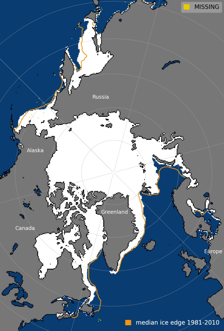
Meanwhile, Arctic sea ice has reached its maximum extent for the year, peaking at 15.01m square kilometres (km2) on 14 March. The provisional data from the NSIDC shows that this year’s Arctic winter peak, despite favourable winds that encouraged sea ice formation, was 640,000km2 smaller than the 1981-2010 average maximum.
This year’s maximum was the 14th lowest in the satellite record.
“Overall, the road remains downhill for Arctic sea ice, but it is quite bumpy along the way,” another scientist tells Carbon Brief. This relatively high winter peak is “notable and a good reminder that we have to communicate and account for this type of weather variability when we talk about Arctic climate change”, he says.
He adds that although the maximum is high compared to recent years, the ice is still “much thinner” than it was a few decades ago. The “wide coverage of this thinner ice” means total Arctic sea ice volume for the month of February was the third lowest on record.
“
The answer seems to lie in the ocean – more warm water getting up to the surface to melt ice or keep it from forming. Is this a temporary effect, or, as many have argued, have we entered a ‘new regime’ in which the ocean will continue to strongly affect the sea ice? Again, we must wait and see.
Dr Mark Serreze, director, US National Snow and Ice Data Centre
Arctic winter peak
Arctic sea ice extent changes throughout the year. It grows each winter before reaching its peak for the year in February or March and then melts throughout the spring and summer towards its annual minimum, typically around September.
Using satellite data, scientists can track the growth and melt of sea ice, allowing them to determine the size of the ice sheet’s winter maximum and summer minimum extent. These are key metrics to monitor the “health” of the Arctic sea ice.
The NSIDC’s announcement says that this year’s Arctic winter peak of 15.01m is “below average”. Clocking in at 640,000km2 below the 1981-to-2010 average maximum extent, it ranks as the 14th lowest in the satellite record.
The NSIDC adds that the date of the maximum this year, 14 March, was two days later than the 1981-to-2010 average date of 12 March.
The plot below shows Arctic sea ice extent on 14 March, with the average sea ice extent for 1981-2010 shown by the orange line.

Arctic sea ice extent on 14 March 2024. Median sea ice edge for 1981-2010 is shown in orange. Source: NSIDC
Arctic freeze
“The road remains downhill for Arctic sea ice, but it is quite bumpy along the way,” Dr Zack Labe – a postdoctoral researcher working at NOAA Geophysical Fluid Dynamics Laboratory and the atmospheric and oceanic sciences programme at Princeton University – tells Carbon Brief. He adds:
“While this winter was yet again consistent with the long-term trend toward a warmer Arctic with less ice, regional weather patterns can still contribute to ice expansion and slower net declines, especially if the winds align from a north-to-south direction.”
Arctic sea ice reached its minimum extent for 2023 on 19 September.
With an extent of 4.23m km2, this was the sixth-lowest minimum on record and 1.99m km2 below the average minimum recorded over 1981-2010.
Following its annual minimum, Arctic sea ice growth was “slower than average”, leading to the fifth-lowest September on record, according to the NSIDC.
Labe tells Carbon Brief that the freeze season started with “widespread open water across the Pacific side of the Arctic, with massive areas of ice missing north of Alaska”, which contributed to “well-above-average temperatures” in the region.
Throughout October, however, sea ice extent increased by 119,800km2 per day – faster than the 1981-2010 average of 89,200km2 per day, according to the NSIDC.
The Arctic freeze up was “particularly rapid” in the seas around Siberia. By the end of October, the ice cover had reached the Siberian coast, although open water remained in the Beaufort and Chukchi Seas.
Air temperatures over the Arctic Ocean, around 2,500 feet above surface level, were mostly above average during October – particularly in and around the Canadian Archipelago, which saw temperatures of 4-5C above average.
Labe tells Carbon Brief that, overall, the Arctic winter can be characterised by “unusual warmth in the northern Arctic, but greater total ice extent”. This “counterintuitive” dynamic was caused by atmospheric circulation patterns, which led to “warmer, moist air blowing toward the north pole, while northerly winds contribute to expanding ice in the Greenland Sea and Sea of Okhotsk”, he says.
Throughout November, Arctic sea ice extent continued to increase faster than average. However, the NSIDC says the freeze up “temporarily stalled” for around five days from 22 November, as a series of three tropical cyclones brought warm, moist air into the north Atlantic.
The NSIDC says that a combination of low pressure to the north and west of Svalbard and a high-pressure centre to the south-east “created a strong, persistent flow from the south of relatively warm and moist air from the north Atlantic Ocean toward Svalbard”.
This flow of air can be seen as “an extension of an atmospheric river into the Arctic”, it says. It adds that the strong winds “helped to push the ice edge in the east Greenland and Barents seas northwards, limiting new ice formation”.
The NSIDC notes that pauses in Arctic sea ice freeze up have happened in November before, in 2013 and 2016, making such events “rare, but not unknown”.
Arctic sea ice extent continued to increase “markedly faster” than usual throughout December, the NSIDC says. It adds that “sea ice formation in Hudson Bay was unusually late, but the ice cover expanded quickly from west to east in mid-December”.
For December overall, 2023 saw the third-highest monthly gain on record, with 2.71m km2 of sea ice extent added throughout the month. Average Arctic sea ice extent over December 2023 was the ninth lowest in the satellite record, at 12m km2.
Arctic sea ice extent continued to move down the rankings as the new year rolled in, despite slower-than-average ice growth. In fact, the NSIDC says that Arctic sea ice extent actually declined for a few days at the end of the month, although it notes that this is “not unusual at this time of year” and says it is “caused by weather systems that temporarily halt ice growth or push the ice northwards”.
The average Arctic sea ice extent for January 2024 was 13.92m km2 – the 20th lowest on record.
This comparatively high sea ice extent is “notable and a good reminder that we have to communicate and account for this type of weather variability when we talk about Arctic climate change”, Labe tells Carbon Brief.
Arctic sea ice extent continued to grow throughout February, gaining 15.3m km2 of ice throughout the month. The February 2024 extent of 14.61m km2 was 690,000km2 below the 1981-2010 February average extent, and tied with 2022 as the 15th lowest on record, according to the NSIDC.
Temperatures are usually “well-below freezing” over the Arctic Ocean in February, but the NSIDC notes that in 2024, they were not as low as usual for the time of year. Over the central Arctic ocean, air temperatures at 2,500 feet above sea level were up to 10C warmer than average.
Labe notes that although sea ice extent was high compared to recent years, the ice is still “much thinner” than it was a few decades ago:
“Total Arctic sea-ice volume ended up as the third lowest on record for the month of February due to the wide coverage of this thinner ice.”
Antarctic ‘behaving strangely’
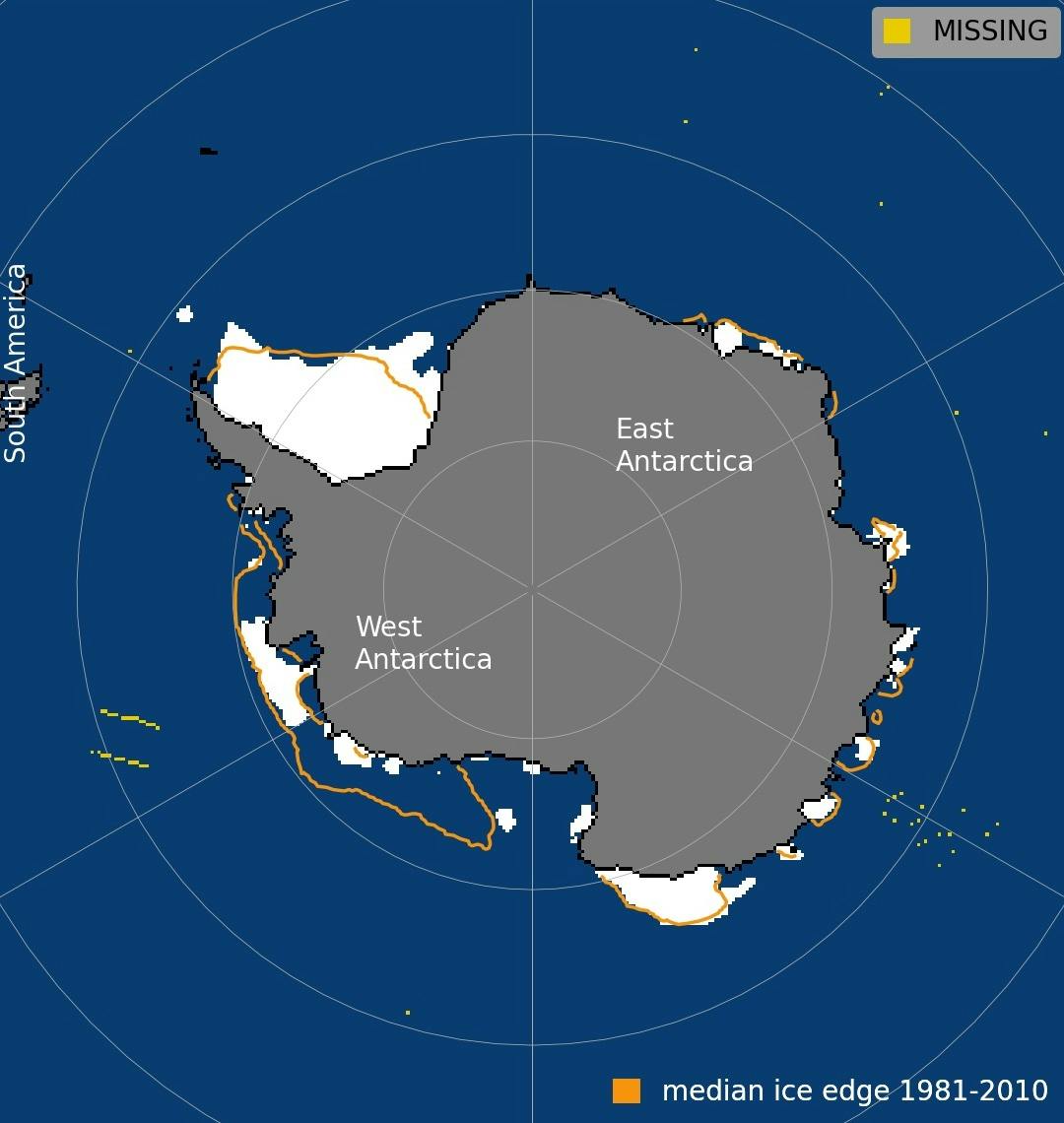
Meanwhile, at the Earth’s other pole, Antarctic sea ice hit its summer minimum sea ice extent on 20 February. With an extent of 1.99m km2, this year’s minimum ties with 2022 as the second-lowest on record, the NSIDC reports.
The plot below shows Antarctic sea ice extent on 20 February 2024, with the median sea ice extent for 1981-2010 shown by the orange line.

Antarctic sea ice extent on 20 February 2024. Median sea ice edge for 1981-2010 is shown in orange. Source: NSIDC.
The Antarctic minimum was 850,000km2 smaller than the 1981-to-2010 average summer low of 2.84m km2, but 200,000km2 larger than the previous record low set on 21 February 2023.
This year marks the third consecutive minimum Antarctic sea ice extent below 2m km2. The table below shows the five years with the lowest minimum Antarctic sea ice extent on record, which includes 2022, 2023 and 2024 towards the top.

Graph: Carbon Brief
“The Antarctic has been behaving strangely,” Dr Mark Serreze, director of the NSIDC, tells Carbon Brief. He continues:
“In the past few years, [southern hemisphere] summer extent has dropped to record lows. Before that, we saw record highs! What has changed?
“The answer seems to lie in the ocean – more warm water getting up to the surface to melt ice or keep it from forming. Is this a temporary effect, or, as many have argued, have we entered a ‘new regime’ in which the ocean will continue to strongly affect the sea ice? Again, we must wait and see.”
Record-breaking Antarctic extent
Antarctic sea ice has been tracking at or near record-low levels for months.
The Antarctic set a record-low maximum on 10 September 2023, with an extent of 16.96m km2. This was “the lowest sea ice maximum in the 1979 to 2023 sea ice record by a wide margin”, and one of the earliest, the NSIDC says.
Antarctic conditions over 2023 were “truly exceptional” and “completely outside the bounds of normality”, one expert told Carbon Brief.
As 2023 progressed, Antarctic sea ice melt was “slower than average”, the NSIDC says. The total decline in Antarctic sea ice extent through October was 903,000km2, while the October average was 985,000km2.
Nevertheless, Antarctic sea ice extent continued to track at a record low. On 31 October 2023, Antarctic sea ice extent was still tracking at a record-low of 15.79m km2. This is 750,000km2 below the previous 31 October record low.
The decline in Antarctic sea ice paused for a few days from 9 November, allowing sea ice extent to creep above the November 2016 value, the NSIDC says. This marked the first time that the daily 2023 Antarctic sea ice extent was not the lowest in the record since early May 2023. By the start of December, Antarctic sea ice extent was again at a record low, it notes.
The Antarctic saw in the new year with a sea ice extent of 6.37m km2, marking the sixth-lowest New Year’s Day Antarctic sea ice extent on record, the NSIDC says. Ice melted rapidly throughout the month, and by the end of January, daily Antarctic sea ice extent reached 2.58m km2 – tying with 2017 for second lowest on record.
This story was published with permission from Carbon Brief.


